

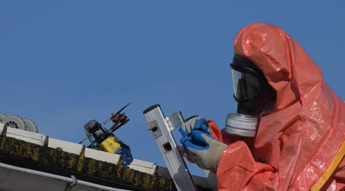
Unmanned systems are becoming integral to how CBRN professionals detect hazards, build situational awareness, and protect personnel. Drones are no longer limited to providing imagery from above. When paired with appropriate payloads, data links, and operating procedures, unmanned aerial vehicles (UAVs) and unmanned ground vehicles (UGVs) can act as forward-deployed sensing platforms: entering contaminated areas, locating and characterising hazards, mapping their evolution, and sending actionable information to commanders before responders are committed to the danger zone. The operational value is clear. CBRN incidents often develop amid uncertainty: an unknown chemical release, a radiological alarm, an industrial fire, an explosive threat, or a complex battlefield environment. Visibility may be poor, access routes blocked, communications disrupted, and the risk to responders initially unclear. In these conditions, an unmanned platform can provide the first credible picture of the scene while reducing the need for personnel to enter it prematurely. The key point, however, is that the drone itself is not the capability. The capability lies in the combination of platform, sensor payload, communications, trained operators, data interpretation, and command-and-control integration.
A remote sensing layer for hazardous environments
For decades, CBRN reconnaissance has depended on trained personnel equipped with handheld detectors, protective equipment, vehicles, and established sampling procedures. These remain indispensable. Yet putting people forward to determine whether an area is safe inevitably exposes them to the very hazard they are trying to understand. Sensor-equipped unmanned systems offer a practical alternative for the earliest stages of reconnaissance. The U.S. Department of Homeland Security notes that UAV-mounted CBRN payloads can remotely detect, identify, monitor, and help characterise hazardous substances. They can survey radiation levels, enter areas releasing hazardous gases, monitor toxic chemicals, transmit information in real time, or collect air samples for subsequent laboratory analysis. This provides responders with access to unsafe or otherwise difficult-to-reach locations while limiting exposure. This has direct relevance across the CBRN spectrum. In a chemical incident, a UAV can combine visual imagery, thermal imaging, meteorological data, and gas measurements to help identify a release point, assess plume direction, and monitor potential ignition sources. In a radiological scenario, a small, manoeuvrable aircraft may approach and survey constrained locations where a ground team would face unnecessary risk. In explosive-hazard operations, unmanned platforms can support route reconnaissance, area observation, and stand-off inspection before technicians move closer. The benefit is not simply faster data collection. It is better sequencing of risk. Personnel can make more informed decisions about protective posture, exclusion zones, evacuation routes, entry points, and the need for specialised assets. In short, unmanned systems can help commanders turn an uncertain and dynamic scene into an operationally manageable one.
Matching the platform to the mission
“Drone” is often used as a catch-all term, but platform choice matters greatly. Fixed-wing UAVs, multirotor UAVs, and UGVs each bring different strengths and limitations. Fixed-wing UAVs generally offer endurance, range, and stable flight characteristics. They are well suited to wide-area surveillance, route reconnaissance, plume tracking over longer distances, or persistent observation of a large site. Their stable airframes can support CBRN payloads, but they normally require space for launch and recovery and are less suited to hovering over a specific point of interest. Rotary-wing UAVs, including quadcopters and hexacopters, offer vertical take-off and landing, hover capability, and agility around structures, industrial installations, and urban terrain. Their ability to change payloads quickly is particularly useful for teams that need a flexible asset rather than a single-purpose aircraft. However, endurance, range, and payload capacity remain significant constraints; a heavier sensor package can reduce flight time, manoeuvrability, and stability. UGVs fill a different but complementary role. They can carry larger, heavier, and more power-demanding payloads than many aerial platforms, including multiple detectors, samplers, weather stations, cameras, and communications equipment. They can also remain in an affected area longer and, where necessary, be left until safe decontamination becomes possible. Their effectiveness depends on terrain, mobility, communications, and vehicle configuration, but for sustained ground-level monitoring and sampling they can be the more capable choice. The most effective operational model is therefore rarely UAV or UGV. It is a layered approach: aerial platforms establish the broad picture, identify priorities, and observe changes; ground platforms conduct close-in confirmation, sampling, and persistent monitoring. The system should be designed around the operational question, not around the available vehicle.
Payloads make the difference
A UAV with a camera provides valuable visual intelligence, but a CBRN mission requires more than imagery. The priority is to integrate payloads that provide defensible data for the specific hazard, environment, and decision requirement. Payload selection may include chemical detectors, radiation detectors, air-sampling systems, bioaerosol sensors, thermal imagers, visual cameras, weather sensors, and positioning or mapping tools. A single platform need not carry everything. Indeed, attempting to place too many sensors on a small airframe can reduce operational performance. Instead, teams should determine what data must be collected, how quickly it is needed, how accurate it must be, and whether a screening result, confirmatory measurement, or physical sample is required. Modular payload architecture is especially important. According to Bertin Environics, modular CBRN systems can be configured or upgraded to suit changing missions, allowing chemical, radiological, nuclear, and bioaerosol detection modules to be deployed as required. Such approaches can also support common data feeds to command centres and to other users of the situational-awareness system. This reflects a broader operational principle: flexibility is more valuable than a one-size-fits-all payload. A reconnaissance flight for toxic industrial chemicals may demand gas detection, wind data, and thermal imaging. A suspected radiological event may prioritise dose-rate measurement, spectral identification capability, accurate geolocation, and close-in manoeuvrability. A large industrial emergency may require several systems working together, with separate aircraft dedicated to wide-area imagery, plume assessment, and communications relay. Integration is as important as sensor selection. Mounts, cabling, power supply, electromagnetic compatibility, sensor warm-up requirements, airflow around an intake, and communications links must all be evaluated. A payload that works well in isolation may produce unreliable results when exposed to rotor wash, vibration, weather, or an unsuitable sampling geometry. Payloads should also be compatible with the platform’s software environment and data-management tools.
From data to decisions
The operational purpose of unmanned CBRN reconnaissance is not to generate more data; it is to enable better decisions. Live video alone can reduce uncertainty, but the greatest value emerges when imagery, detector readings, weather observations, maps, and personnel locations are brought into a common operational picture. In chemical-leakage response, for example, UAVs can collect real-time imagery, temperature data, gas concentrations, and information on fire or liquid-release patterns. Used correctly, this information can support the creation of hazard maps, evidence-based exclusion zones, evacuation routes, and safer access routes for responders. It can also reduce reliance on incomplete verbal reports when multiple agencies are operating under pressure. Aerial systems can also support coordination. By sharing the same live video and sensor data with fire and rescue, medical services, law enforcement, environmental specialists, and incident command, organisations can work from a more consistent picture of the situation. This does not eliminate the need for a clear command structure, but it can shorten the time between observation, assessment, and action. Artificial intelligence may strengthen this process through assisted mapping, anomaly detection, route planning, sensor fusion, and prioritisation of areas for inspection. It should not, however, replace expert CBRN judgement. Automated tools can help identify patterns, but trained personnel must assess detector confidence, environmental effects, false-alarm potential, operational context, and the implications for protective actions.
Beyond reconnaissance: Emergency response and casualty care
The role of unmanned systems in CBRN operations is expanding beyond detection and reconnaissance. They can also support logistics, communications, triage, and casualty evacuation when conventional access is blocked or when sending personnel forward would create unacceptable risk. This is no longer only a conceptual capability. In October 2026, Ukrainian forces reported evacuating a wounded soldier from a front-line position using a heavy-lift aerial drone after conventional ground evacuation was judged too dangerous because of landmines and hostile drone activity. According to reporting on the operation, the casualty secured himself using a specially designed harness while the drone transported him to safety; he subsequently received medical treatment and rehabilitation. Ukrainian military sources described the mission as the first aerial-drone evacuation of a wounded soldier from the front line, although that “world-first” designation has not been independently verified. The operation demonstrates the potential of unmanned casualty evacuation in environments where vehicles, stretchers, or rescue personnel cannot safely reach a casualty. It also reinforces the relevance of concepts such as the European Defence Fund’s iMEDCAP programme, which integrates UAVs, UGVs, patient transport systems, telemedical monitoring, and robot-assisted care into a coordinated evacuation architecture. Rather than treating these systems as distant future technologies, the Ukrainian case shows that battlefield necessity is already accelerating their operational use. However, a successful field evacuation should be viewed as an important operational proof point, and not as evidence that unmanned medical evacuation is ready for routine, large-scale deployment. Broader adoption will still require validated patient-safety procedures, reliable casualty-restraint and monitoring systems, robust communications, trained personnel, cybersecurity protections, and clear legal and ethical frameworks. In CBRN settings, these requirements are even more demanding because patient transport may also involve contamination control, decontamination planning, and protection of medical personnel and receiving facilities.
Practical constraints that must be addressed
Unmanned systems are not a substitute for CBRN doctrine, trained specialists, or confirmatory analysis. Their limitations need to be recognised early in programme design and exercised regularly. First, environmental conditions can compromise both aircraft and sensors. Wind, rain, extreme temperatures, smoke, dense urban terrain, electromagnetic interference, and GPS-denied locations may affect flight performance, navigation, communications, and measurement quality. Second, payload limitations require disciplined mission planning. Small platforms offer access and agility but may carry only limited sensors for a limited duration. Larger systems bring greater capability but may demand more personnel, transport, airspace coordination, and logistical support. Third, cybersecurity and data resilience are operational requirements, not optional technical details. Systems that depend on wireless links, cloud services, or software updates must be protected, maintained, and backed up. Loss of link procedures, data integrity, secure communications, and access control should be incorporated into training and exercises. Finally, operators need more than flight skills. They must understand detector limitations, contamination control, sampling principles, geospatial reporting, airspace safety, and how to communicate findings in a form that supports incident command. CBRN teams should train with UAV and UGV operators as an integrated capability, and not as separate technical communities.
The next operational standard
Drones are reshaping CBRN operations because they create distance between people and danger while bringing actionable information closer to decision-makers. Their greatest contribution is not replacing specialists or response teams; it is giving those teams a safer, faster, and more comprehensive basis for action. The next standard for unmanned CBRN capability should be mission-led and modular: the right platform, the right payload, secure communications, interoperable data, trained operators, and specialist interpretation. When these elements are integrated, UAVs and UGVs become more than remote-controlled assets. They become a protective sensing layer for detection, reconnaissance, and emergency response in the most demanding environments.